


Área de título y declaración de responsabilidad
Título apropiado
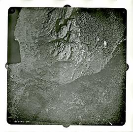
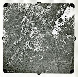
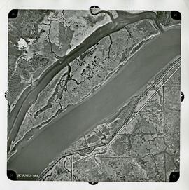
Aerial Photographs
Tipo general de material
- Material gr?fico
Título paralelo
Otra información de título
Título declaración de responsabilidad
Título notas
Nivel de descripción
Serie
Código de referencia
Área de edición
Declaración de edición
Declaración de responsabilidad de edición
Área de detalles específicos de la clase de material
Mención de la escala (cartográfica)
Mención de proyección (cartográfica)
Mención de coordenadas (cartográfica)
Mención de la escala (arquitectónica)
Jurisdicción de emisión y denominación (filatélico)
Área de fechas de creación
Fecha(s)
Área de descripción física
Descripción física
141 photographs : b&w ; 25 x 25 cm
186 photographs : b&w ; 23 x 23 cm
1 map : 17 x 23 cm
1 map : 19.5 x 24 cm
Área de series editoriales
Título apropiado de las series del editor
Títulos paralelos de serie editorial
Otra información de título de las series editoriales
Declaración de responsabilidad relativa a las series editoriales
Numeración dentro de la serie editorial
Nota en las series editoriales
Área de descripción del archivo
Nombre del productor
Historia administrativa
The Dept. of Lands, Forests and Water Resources was established in 1908 under its first name, the Dept. of Lands (Department of Lands Act, SBC 1908, c. 31). Before 1908 the agencies responsible for the functions of the Dept. of Lands, Forests and Water resources were: (1) the Dept. of Lands and Works (Crown lands management, sales, pre-emptions and leases, lands surveying and mapping, timber inspection, forest protection and log scaling), and (2) the Dept. of Mines (water rights in regards to mining operations). The Dept. of Lands, headed by the Chief Commissioner of Lands, was given responsibility for public lands and water rights, and all matters connected therewith. (SBC 1908, c. 31, s. 5). These responsibilities included: (1) the management of all public lands, as per the Land Act, (RSBC 1897, c. 113); (2) administration of water rights, as per the Water Clauses Consolidation Act, (RSBC 1897, c. 191) [in 1892 by means of the Water Privileges Act (SBC 1892, c. 47), the government had reserved to itself the right to manage all water resources in the province that were unreserved and un-appropriated as of April 23, 1892]; and (3) land settlement programs for returned soldiers. In 1909, the enactment of the Water Act (SBC 1909, c. 48) resulted in the creation of the Water Rights Branch of the Dept. of Lands, under the management of the Chief Water Commissioner (re-named Comptroller of Water Rights in 1912). This legislation also resulted in the creation of Water Districts under the management of District Engineers, who would be responsible for management in the field of the Branchs responsibilities. In 1911, the Timber Department, including Timber Inspectors, forest protection services and log scaling operations, was transferred from the Dept. of Public Works to the Dept. of Lands. In 1912, the management of timber resources was formally added to the departments responsibilities with the enactment of the Forest Act (SBC 1912, c. 17). To accommodate these new responsibilities, the Forest Branch, under the Chief Forester, was created in the Dept. of Lands. In 1945, the Dept. of Lands was renamed the Dept. of Lands and Forests (Department of Lands Act Amendment Act, SBC 1945, c. 45). At this time, the department was reorganized into two branches, the Lands Service and the Forests Service. In 1962, the Dept. of Lands and Forests was renamed the Dept. of Lands, Forests, and Water Resources (Department of Lands and Forests Act Amendment Act, SBC 1962, c. 22). At this time, the department was reorganized into three branches, the B.C. Lands Service, the B.C. Forest Service, and the B.C. Water Resources Service. On December 23, 1975, the Dept. of Lands, Forests and Water Resources ceased to exist. The government established two new agencies, the Dept. of Forests and the Dept. of Environment, to replace it (OIC 3838/75). All activities associated with the forestry function were transferred to the Dept. of Forests (OIC 3849/75, 3868/75). With one minor exception, the remaining functions of the Dept. of Lands, Forests, and Water Resources were transferred to the Dept. of Environment (OIC 3843/75, 3844/75, 3846/75, 3852/75). In 1976, these organizational changes were reiterated in legislation (SBC 1976, c. 18)
Historial de custodia
The photographs were purchased by the Planning and Development Department. The photographs were transferred to the Archives in 2016.
Alcance y contenido
The series consists of aerial photographs taken by the Department of Lands, Forests, and Water Resources in 1963 and 1969.
Área de notas
Condiciones físicas
Arreglo
Idioma del material
Escritura del material
Ubicación de los originales
Disponibilidad de otros formatos
Restricciones de acceso
Condiciones de uso, reproducción, y publicación
Public Domain
Instrumentos de descripción
Materiales asociados
Acumulaciones
Nota general
The Series was originally S02 in the Corporation of the District of Coquitlam fonds (F41).